Choosing a Program in the Department of Geosciences
We're proud to offer a wide variety of degree programs in our department, but we also realize that sometimes having a lot of choice can be overwhelming! On this page we run down the different options and talk about the kinds of territory and careers that can go with each. Many of the different options have overlap with one another in terms of the required courses, but they all provide different focuses. If you have a specific career in mind and are curious about how that might work for you, you can always talk to one of our faculty about career mentoring!
Geoscience B.S.
This major includes five different career tracks across two concentrations covering various aspects of the study of the Earth and our relationship to the natural world.
Geology Concentration
Professional geologists and Earth scientists work outdoors in the field and indoors in laboratories and offices. The field may be at in the ocean or on land in mountains, plains, deserts, or polar ice sheets. They may work in a government agency or at a private company. Almost all geologists and Earth scientists identify and describe samples of the natural materials (soil or sediment, minerals or rocks, fossils, water or ice) which they collect and study.
Sampling of Earth materials requires a broad range of equipment, from simple rock hammers to massive drilling rigs. Final identification and description of these samples usually requires use of laboratory instruments including X-ray fluorescence, electron microscope, seismograph, ground penetrating radar, polarizing optical microscope, mass spectrometer, geographic information systems, as well as other specialized software.
- Geology Track - For students who want careers as professional licensed geologists. Program Coordinator is Dr. Warner Cribb.
- Earth Science Track - For students interested in technical and non-technical geoscience related careers. Program coordinator is Dr. Mark Abolins.
- Earth Science for Teachers Track - For students who want to be secondary education teachers. Program coordinator is Dr. Mark Abolins.
Physical Geography Concentration
Physical geographers’ ability to analyze and integrate aspects of the Earth’s physical and human environments makes them attractive for a variety of jobs. The training in computer-based cartography, remote sensing, and the use of geographic information systems that geospatial analysis graduates receive is especially valuable as this tech is a major growth area in all areas of the professional geosciences.
Career options include working for planning, emergency management, environmental, and conservation agencies at all levels of government as well as military contracting. In industry, many firms including retail chains, financial institutions, insurance companies, and real estate agencies employ geographers to collect and analyze data that relate to the services they provide. A range of NGOs working in areas of the environment, sustainability, and the protection of indigenous ways of life are available too. The program coordinator for Physical Geography is Dr. Jeremy Aber.
- Physical Geography Track - For students who want to be geographers with a focus on the natural world.
- Geospatial Analysis Track - For students who want careers working with geospatial technologies.
Environmental Science B.S.
The Environmental Science major only has one concentration, but there are plenty of options within the major requirements to tailor the degree to the areas you're interested in! Environmental scientists work in a variety of careers across all sectors of the economy. Given the challenges of climate change and the need for more environmentally sustainable ways of life that humanity faces, the work of environmental scientists is more important than ever before.
The combination of knowledge from geosciences, chemistry, biology, and geospatial technologies positions graduates for careers in a variety of federal, state, and local government positions dealing with the environment, planning, and sustainability. In the private field, many companies large and small need environmental consulting to help improve their sustainability and reduce their carbon footprints. Federal predictions show a much faster level of growth for these kinds of jobs compared to the overall job growth rate for the next decade.
The program coordinator for the Environmental Science degree is Dr. Racha El Kadiri.
Geoscience M.S.
The Master of Science in Geosciences degree has two tracks: professional sciences and thesis research. The multi-disciplinary nature of the program offers opportunities to develop new skillsets in geospatial sciences (Geographic Information Systems, remote sensing, spatial analysis) and environmental geosystems (hydrogeology and watershed systems) that complement/enhance undergraduates experiences and backgrounds. While all of our undergradute tracks would prepare you to join the M.S. program, we have had many students successfully complete the program who started with with degrees in anthropology, physics, business, archeology, biology, computer science, and others. The program coordinator for the M.S. program is Dr. Henrique Momm.
- Professional Science Track - For students who want to combine business and science coursework to develop necessary science proficiency while simultaneously developing workplace skills. The program is designed to be completed in two years and it culminates with a professional internship.
- Thesis Research Track - For students who wish to complete a traditional research thesis project. Students, in consultation with a faculty member, define a thesis committee and work on a research project (field, laboratory, computer simulation, geospatial analysis, etc). This experience prepares students for specialized professional positions and doctoral programs.
Faculty Spotlight
Click the image above to see a larger version.
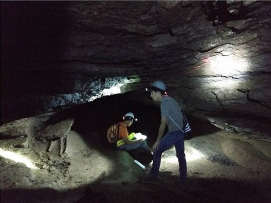
Dr. Mark Abolins teaches a course about earthquakes and folded and fractured rocks (Geol 4080/5080 Structural Geology), a Field Methods in Geology course (Geol 3050), and an on-line course about caves (Geol 3040 Geoscience of Caves). His research foci include (a) the development of caves within folded and fractured rocks, (b) the geology of continental interiors, and (c) the accuracy of geologic maps. In the computer sphere, he uses geographic information system (GIS) software and Midland Valley MOVE structural geology software in teaching and research. He has incorporated state-of-the-art local and global LiDAR (light detection and ranging) elevation datasets into his work.

