Locating Tennessee Manufacturers That Export 2nd Quarter 2016
Tables and Graphs
The Commerce Department recently released its 2014 exporter database. This includes a breakdown of the location of every American firm that exported during the year. Here we use this data to examine the geographical location of Tennessee's manufacturing exporters. One can argue manufacturing firms are particularly important for assessing the export performance of a region or locale. First, the large majority of exports come straight from manufacturing operations. About 60% of the value of national exports comes directly from manufacturers (as opposed to wholesalers, trading firms, and other types of exporters). Second, for manufacturing, the economic activity associated with exporting can be clearly assigned to the local community where the manufacturer is located. Other types of exporting firms may be shipping goods fabricated at some distance from the firm itself.
Just under 3,000 Tennessee manufacturers exported in 2014. That number increased by 64 firms from 2013. (This is net. In any given year, there are new exporters but also previous exporters that did not ship anything overseas that year.) About 40 percent of all Tennessee exporters are manufacturers, which is actually significantly higher than for the U.S. generally. Nationally only about a quarter of exporting firms are manufacturers. This is another sign that the state economy is unusually "invested" in manufacturing.
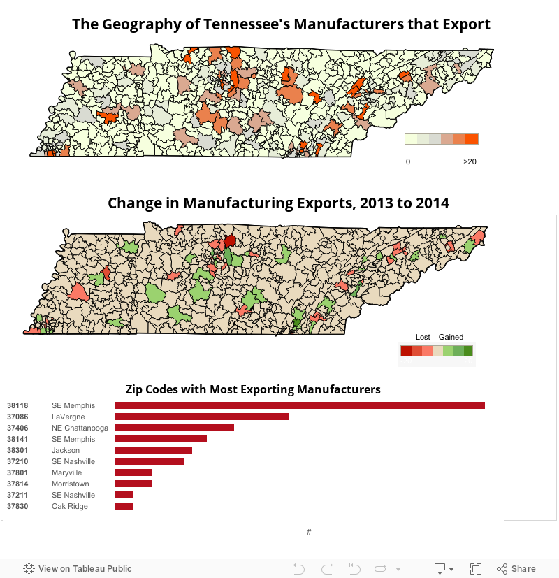
The accompanying map [ see map ] shows the geographical spread of state manufacturing exporters using their five-digit zip codes. A second map shows the change from the previous year. The maps show the relative concentration of manufacturing exporters in the state. A total of 257 of the state's 680 five-digit zip codes do not contain a single manufacturing operation that exports.* On the other hand, the state has 10 zip codes with more than 30 exporting manufacturing firms each. Together these top 10 account for 15% of the statewide total. (Six of these 10, by the way, adjoin one of the state's major airports.)
Particularly when examining both maps together, we can see some trends. The geographically largest area of heavy exporting is around Nashville. This region is growing in all directions, though particularly east and south towards Chattanooga. We see a similar spread in the region from Oak Ridge to Knoxville. Chattanooga and Memphis both have heavy concentrations of manufacturing firms that export, but they are more geographically concentrated around the central city (with Chattanooga area manufacturers expanding northeast of the city). However, a second trend shown by the gains and losses is that exporting firms are moving from the center of the state's metropolitan areas to the greenfield belts that surround them. This is particularly noticeable around Nashville and Chattanooga but can be seen for Memphis and Knoxville as well.
Data at this level of detail has only been available for the past several years. As 2015 and 2016 data become available, we will be able to build a more complex picture of how the pattern of state exporting is evolving, which should prove very interesting.
* There are more than 680 five-digit zip codes in the state, but a number have no specific geographical coordinates and are instead associated with P.O. boxes or buildings. Exporters with such zip codes (and they do exist!) were placed in the zip code that surrounds their location for purposes of building the maps and writing this summary.

